Wave and Land Out at Hood River
Ian Henehan - December, 2000
I launched at about 1:30. The tow was pretty rough all the way to the ridge. As we climbed to 2400' AGL, I noticed that the vario was going off the scale, so I released. The ridge was working very well with lift of 3-5kts. I kept an eye on George and Gary as they made their way west and south towards the airport. Lift over the valley was pretty consistent, though the rate of climb varied quite a bit. I was averaging around 3kts most of the time but hit 7-8kts several times for a few minutes. The clouds were scattered over the valley and would force us to fly around them as they moved towards the ridge.
Around 8000'MSL we contacted wave and climbed above the cloud tops around 9000' MSL. Once above the clouds, it wasn't too difficult to stay in the sweet spot, which was almost directly over the field. Rate of climb was consistent at 4kts up to 12,500'MSL. I didn't have oxygen on board, so I didn't want to climb any further. I lowered the nose and was doing about 75kts when I leveled out at 12,800'MSL. I thought I'd try to crab towards Mt. Hood and see if I could get closer.
After flying to the south for about five minutes, I encountered about 6kts of sink. I turned back towards the west and maintained my speed around 70-75kts, to get back towards the airport and out of the sink. If anything, the sink rate was increasing and now cloud cover obscured the airport and ridge. There were large holes in the cloud cover west of the field and east of the ridge, but I was sinking too fast to make it west. By the time I was closing on 9000'MSL, I knew I would have to descend through the breaks to the east of the ridge.
I dropped below the tops of the clouds around 8500'MSL. Now I was forced to fly a track to the north to stay clear of the clouds and keep the ground in sight. As I passed through 7000'MSL, I realized that I had been blown well east of the ridge. To make matters worse, I had to dive so that I could get under the clouds advancing from the west. AT 5000'MSL, I was still about 2 miles east of the ridge. Now the sink rate had increased to 8-10kts as I was flying through the downdraft on the backside of the ridge. At 4000'MSL, it was becoming apparent that I would not clear the ridge, let alone make the field.
I took a track that put me over the Columbia River by the time I hit 2500'MSL. Van was flying near the ridge and we had been talking about my position. At about 2000'MSL, I let him know that I was not going to make it to the field. I flew away from the ridge and over the river. At about 1300'MSL I flew out to the sink. I had descended from 12,800'MSL to pattern altitude in less than twenty minutes!
At this point I had two landing options. One, I try a water landing close to the shore, or two, I land somewhere near the lumber mill on the Washington side of the river. There was nothing appealing about landing in the river, so I took a good look at the mill area. The mill uses a small spit of land in the river for log piles. There were log piles on the east end but not the west. I estimate the length of the spit at 2000'-3000'. Past the log piles, there were individual logs every twenty or so feet, perpendicular to my path and on the right side. There were also several large concrete and steel lumber racks scattered around just east of the center. This leaves about half the length and two thirds of the width to work with. The rest of the area was covered with mud puddles and big ruts left from trucks. It all looked VERY soft. It was still a much better choice than the river.
The wind was still strong, even at this altitude, so I didn't have a chance to fly over the area for a closer look at obstacles. I let Van know where I was headed and then set up for final. I adjusted my descent with a few shallow S-turns and then the spoilers. I flew over the log piles at about 150'-200'. I could now see the lumber racks clearly, as the steel I-beams stuck up a good 15-20 feet. I tried to line up roughly parallel with the road on the right, but saw more logs in the mud and had to stick with the middle of the mud. I kept some spoiler on until I was a few feet off the ground. Without any new obstacles rearing up, I closed the spoilers and started raising the nose to slow down, trying to stay within a couple feet of the ground.
When I reached stall speed I let the plane plop down in the mud. I was expecting to get bogged down and flip over, but I was just hitting the high spots between the ruts. Nothing left to do but hang on and wait. When the weight of the plane transferred to the wheel, the nose pitched down, but did not dig in. I rolled/skidded/slid about 100-150 feet and came to rest. Once I realized that I had survived, I got on the radio and let Van know I was down and OK. He relayed the information to the folks on the ground so that a retrieve could be made.
I got and took a look at the plane and everything seemed fine. There wasn't even mud caked up in the wheel well. Turns out, the ground was covered with mostly wood chips and bark dust, it was spongy, but not muddy. There was a lot of standing water, but the ground was fairly firm. Mill security drove out to see if I was alive and with that confirmed he said he'd keep an eye out for the retrieval crew. Another mill employee came out to take a look at the glider. Apparently he soloed a 2-33 at Hood River about ten years ago. After a short wait, George and Andy showed up with the trailer. Disassembly went without a hitch and we didn't have any trouble driving the trailer out of the mud and water.
The whole flight only lasted one hour and twelve minutes. I had spent 45-50 minutes climbing and the rest falling. There were several personal firsts on this flight. This was the first time I had really contacted wave, the first time I had reached 12,500' and of course, my first land out. I'm looking forward to repeating the first two activities. I can do without the excitement of the land out. The environment at Hood River is challenging and requires vigilance. I hit sink at over 12,000' within a mile or two of the field, and was not able to make it back!
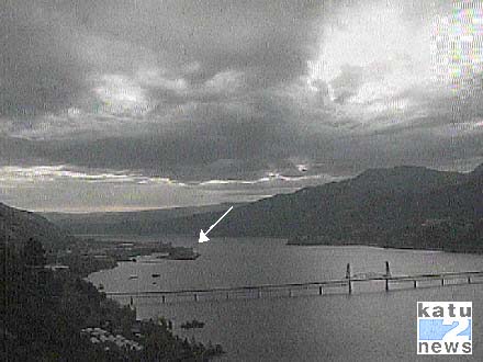
 The LZ
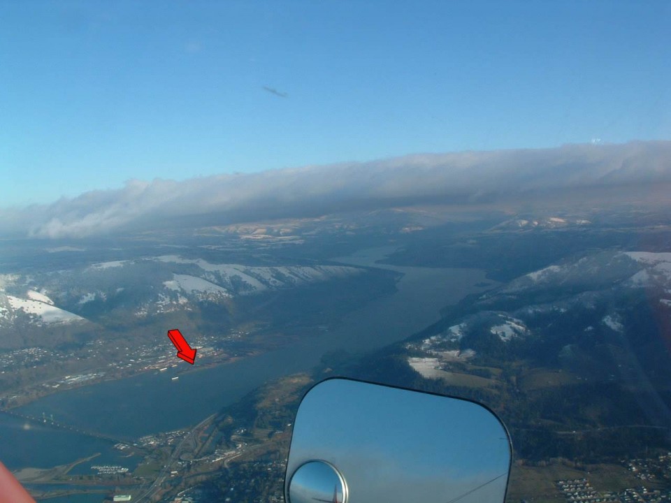
 A better view of the landing area from one of the towplanes.
View Landout in a larger map